Forest Service Burns Slash Piles in Gallinas Mountains; Smoke May Drift Into Estancia Valley
Crews with the Cibola National Forest plan multi-day pile burning on up to 645 acres southeast of Willard, starting Wednesday, October 28, 2026.
Residents of Willard, Cedarvale, and other parts of the Estancia Valley may see or smell smoke this week. Firefighters with the Cibola National Forest and National Grasslands are burning piles of brush and woody debris in the Gallinas Mountains.
The Mountainair Ranger District began pile burning on Unit 2 of the Pueblo Colorado project on Wednesday, October 28, 2026, according to a release posted to NM Fire Info and a text message sent out today by the Mountainair Ranger District. Forest officials said the work may continue for several days if weather conditions stay favorable.
Where the Burn Is Happening
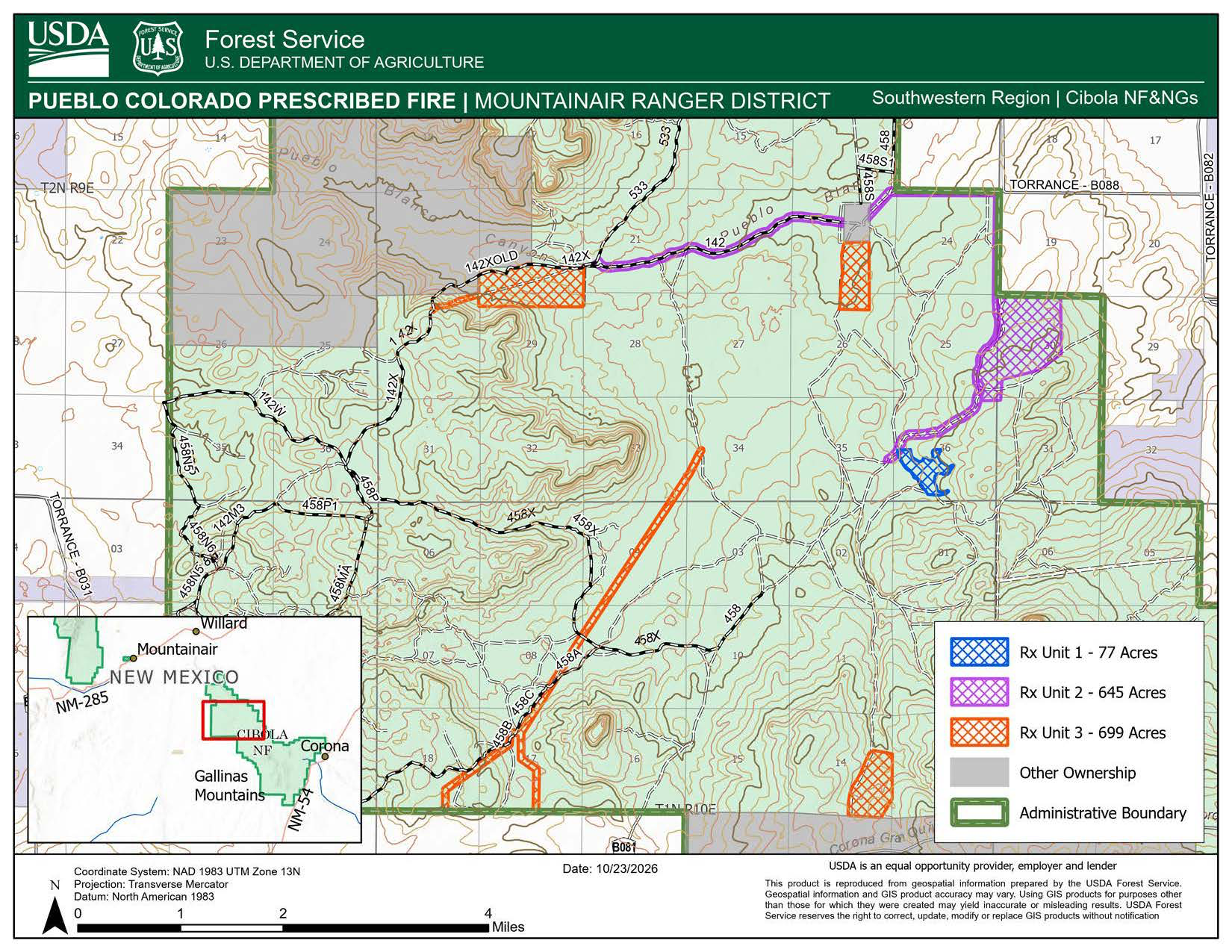
Unit 2 — 645 acres within a Coordinated Resource Management Project in the northern Gallinas Mountains — is in the southern tip of Torrance County, located southeast of Willard and about 15 miles northwest of Corona.
According to a Forest Service map of the project (see above), Unit 2 is in the northeastern part of the project area. It follows Forest Service Road 142 through Pueblo Blanco Canyon and runs south along the eastern edge of the national forest boundary, near Torrance County roads B088 and B082.
The project map also shows two other units, Unit 1 and Unit 3, but the Forest Service said this week's burning is limited to Unit 2.
No closures are planned, but forest officials asked visitors in the Gallinas Mountains to stay alert while firefighters are working in the area.
What Residents Should Expect
Smoke may be visible from Willard, Cedarvale, Corona, and elsewhere in the Estancia Valley. Forest officials said smoke should rise and disperse during the day, but cooler overnight temperatures may cause it to settle into low-lying areas near the burn site, especially in the early morning hours.
People with asthma, heart conditions, or other respiratory problems should pay close attention to air quality. Current smoke conditions are available on the AirNow Fire and Smoke Map, which is also available as a free app. The New Mexico Department of Health offers guidance on judging smoke levels by visibility through its Environmental Public Health Tracking portal.
Why the Forest Service Burns Piles
The piles are made of slash, the branches, small trees, and other woody debris left behind after forest thinning and restoration work. Crews stack that material into piles and leave it to dry, often for a year or more, before burning it.
Fire managers usually burn piles in late fall and winter. Cooler temperatures, higher relative humidity, and moisture on the ground help keep fire contained to the piles rather than spreading into surrounding grass and trees. Forest officials said recent precipitation, cooler weather, and improved humidity created suitable conditions for this burn.
Removing the piles reduces the amount of fuel available to a future wildfire. Left in place, dry slash piles can make a wildfire burn hotter and spread faster.
Context for Torrance County
This burn follows an active fire year in and around Torrance County, including the Deer Canyon Fire south of Mountainair in June and the Whiskey Fire northwest of Mountainair in August.
Stay Informed
Questions about the burn can be directed to the Mountainair Ranger District office at 40 Ranger Station Road, Mountainair, NM 87036, or by phone at (505) 847-2990. More information about the forest is available on the Cibola National Forest and National Grasslands website.
Torrance County residents are also encouraged to sign up for TextMyGov emergency alerts to receive real-time notifications tailored to their needs:
- Text TORRANCE COUNTY to 80946 for general notifications and emergency alerts.
- Text TORRANCE FIRE ALERTS to 80946 for information on prescribed burns or active fires in the area.
- Text TORRANCE NWS to 80946 to receive weather-related alerts.