
Whiskey Fire Grows to 351 Acres as Blanco, Cerro Fires Near Containment
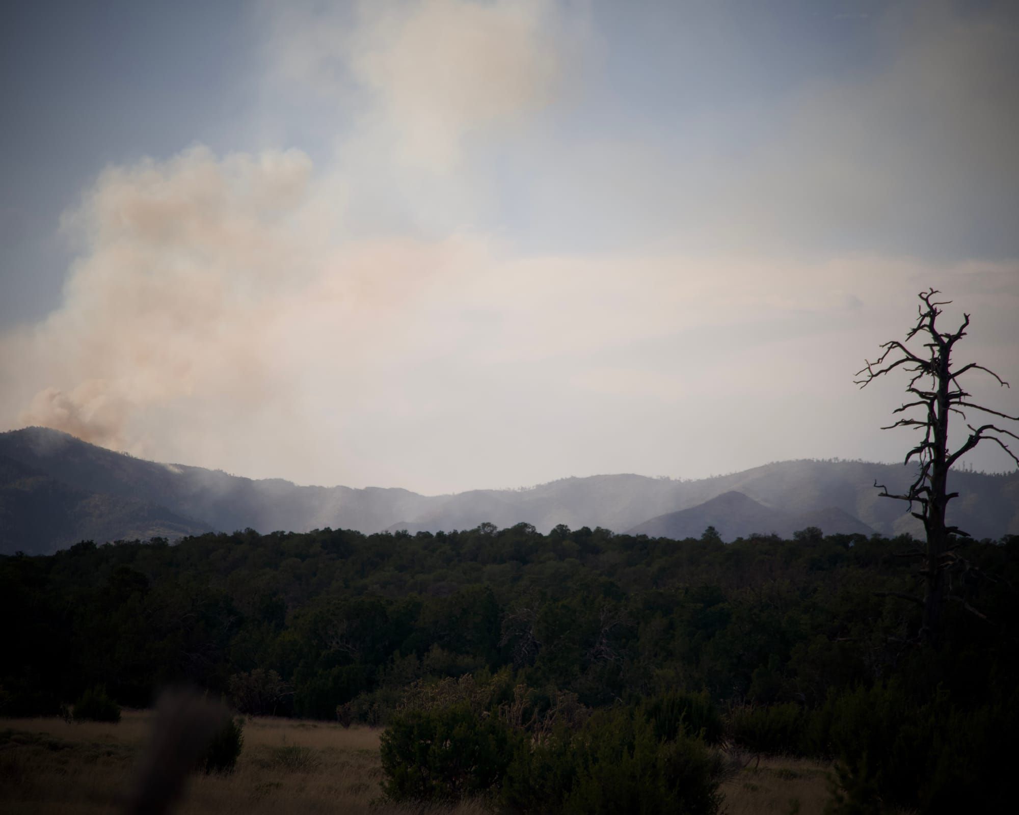
Closure orders remain in effect through September as crews shift from the two smaller blazes to the growing Manzano Mountains wildfire
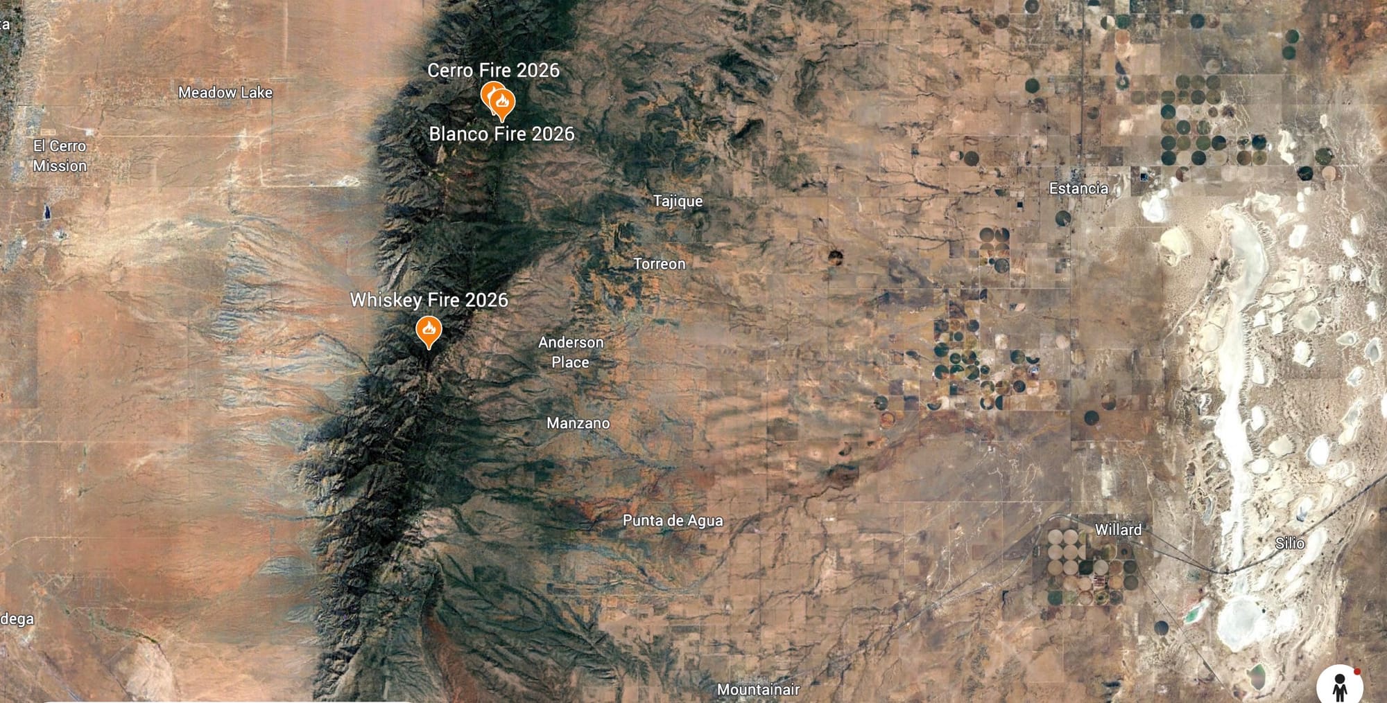
MOUNTAINAIR — The Whiskey Fire burning in the Manzano Mountain Wilderness has grown to at least 351 acres, according to the wildfire tracking service Watch Duty, up from the 250 acres the US Forest Service confirmed in its most recent written update and up sevenfold from the 50 acres reported when the Dispatch first covered the three Manzano Mountains fires on Wednesday, August 26, 2026. The fire has not been contained at any point since it was reported August 21, 2026.
The Blanco and Cerro fires, by contrast, remain close to where the Forest Service last reported them on Friday, August 28, 2026. Watch Duty shows Blanco at 21.4 acres, essentially matching the agency's 21-acre figure, and Cerro unchanged at 7 acres in both sources. The Forest Service has stopped issuing daily updates on the two smaller fires and has begun moving firefighters off them and onto the Whiskey Fire.
The shift matters for residents across a wide stretch of Torrance and Valencia counties, where smoke from the Whiskey Fire has been visible as far away as Belen, Los Lunas, Peralta and Bosque Farms, and where closure orders covering popular recreation sites, including the Fourth of July Campground and Inlow Youth Camp, remain in effect through the end of September.
Whiskey Fire now the priority
According to the Forest Service's most recent release, sent to the Dispatch at 1:25 AM MDT on Sunday, August 30, 2026, and covering conditions the previous day:
- Size: 250 acres (Forest Service); 351 acres (Watch Duty, a wildfire tracking service that aggregates satellite detection, public safety radio traffic and crowdsourced reports and is not an official government source)
- Containment: 0 percent
- Personnel assigned: 131
- Cause: Lightning, reported by Capilla Peak Lookout at 1:50 PM MDT on Friday, August 21, 2026
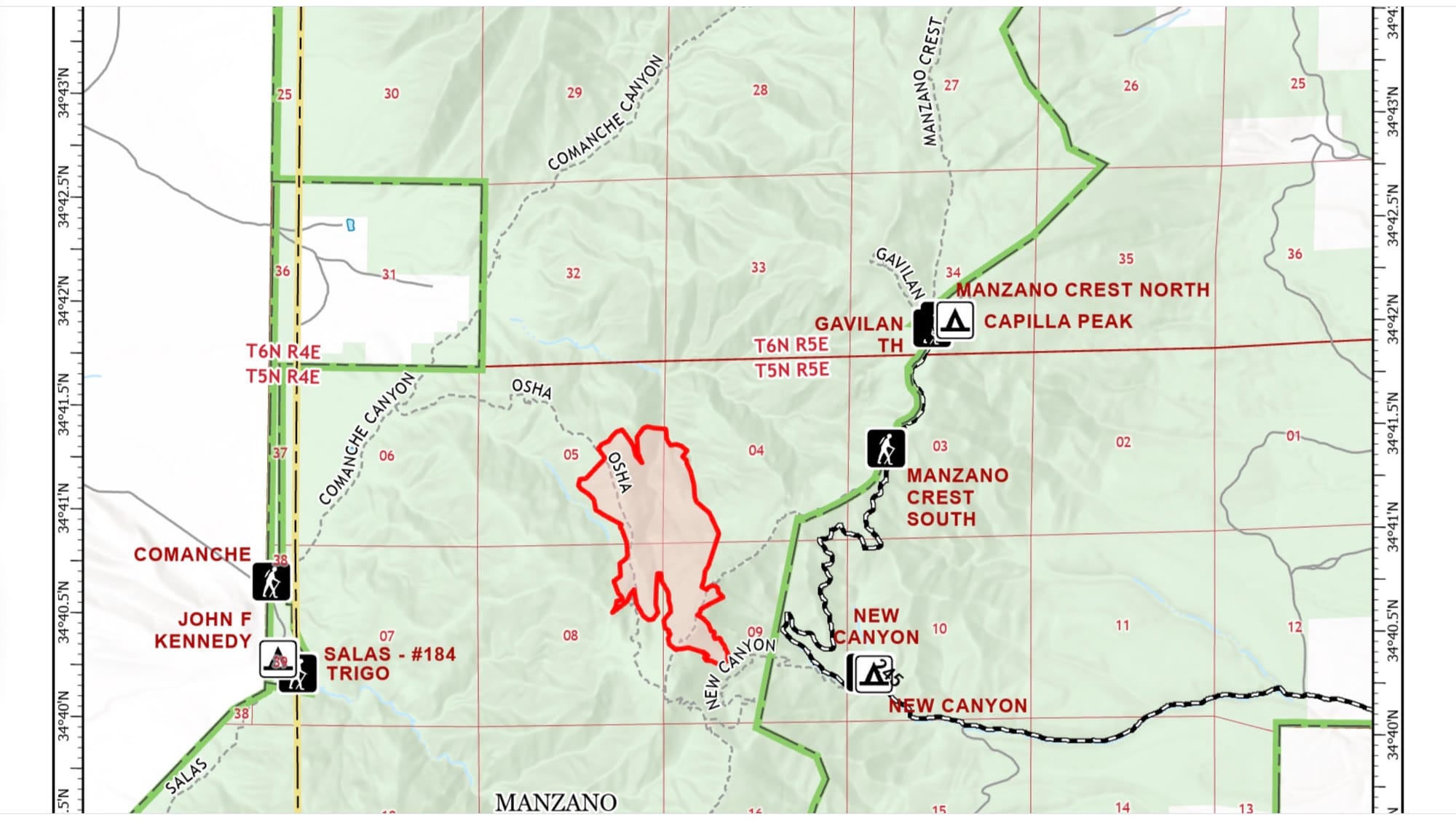
- Location: Steep terrain north of Osha Peak, south of Capilla Peak and west of the Manzano Crest Trail, in and around the Jaramillo Drainage
- Fire behavior: Moderate, down from "high" in the Forest Service's August 28, 2026, update
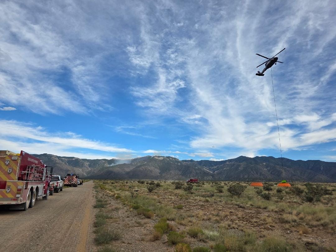
Crews are building indirect fire line on both sides of the fire rather than attacking it directly, a reflection of the steep, inaccessible terrain that has made direct extinguishment difficult since the fire started. On the west side, hand crews are constructing line from the Comanche Trail and preparing the trailhead as a fallback position should the fire back down the drainage. A dozer has arrived to build contingency line on Forest Service land outside the wilderness boundary, including around private inholdings, to protect infrastructure. A grader crew is improving roads to give crews better access to forward operating bases.
On the east side, hand crews and an engine are building indirect line down from the ridgeline near New Canyon, tying into rock outcroppings and other natural barriers. Crews have also cleared vegetation and built line around communication and fire lookout infrastructure, sensitive archaeological sites, Capilla Peak Campground, and area springs.
The Forest Service has also established an aerial drone route near Capilla Peak to fly reconnaissance over the fire and feed crews current information on fire activity and terrain in spots that are difficult to reach on foot.
A Forest Service map dated August 28, 2026, shows the Whiskey Fire's perimeter as of August 27, 2026, burning in the drainage between the Comanche trailhead to the west and the New Canyon trailhead to the east, south of the Manzano Crest South trail junction and north of Osha Peak, entirely within the Manzano Mountain Wilderness boundary. That perimeter predates both the Forest Service's 250-acre figure and Watch Duty's 351-acre estimate.
Blanco, Cerro fires wind down
The Blanco and Cerro fires, both reported August 24, 2026, have not grown since the Forest Service's August 26, 2026, update, according to the agency's August 28, 2026, release, which stated it would be "the final update for the Blanco and Cerro Fires unless changing conditions warrant additional information." No update on either fire followed in the Forest Service's subsequent release, consistent with that statement, and Watch Duty's current figures for both fires closely match the agency's last report.
Blanco Fire: 21.4 acres (Watch Duty). Containment 30 percent. Cause remains undetermined. Firefighters completed hardening handlines around the entire fire before being reassigned to the Whiskey Fire.
Cerro Fire: 7 acres, containment 30 percent, in both sources. Cause was lightning. Firefighters completed handlines around the fire and had been mopping up hot spots before redeployment.
Neither fire has been declared fully contained, and the closure order covering both remains active.
Closures remain through September
The Forest Service issued area, road and trail closure orders covering National Forest System land around all three fires effective 8:00 AM on Wednesday, August 26, 2026. The orders run through 11:59 PM on Wednesday, September 30, 2026, unless rescinded sooner.
- Closure Order 03-03-04-26-18 covers land surrounding the Whiskey Fire.
- Closure Order 03-03-04-26-19 covers land surrounding the Cerro and Blanco fires.
Road closure barricades are in place on Trigo Springs Road. The full text of both orders and accompanying maps are available on the Cibola National Forest's alerts page. Torrance County Emergency Manager, Samantha O’Dell, stated via email on August 30, 2026, that there are no evacuation orders in effect. “Torrance County Emergency Management is working closely with the team to monitor the fire and have discussed pre-evacuation plans, to ensure residence are properly notified if evacuations should be necessary.”
“No Fly Zone” violation prompts renewed warning
The Forest Service alleged that, on August 28, 2026, someone violated the temporary flight restriction in place over the Whiskey Fire operations area, and issued a reminder to the public that the wildfire location is a no fly zone. Privately owned aircraft, including drones, are prohibited from entering fire airspace because they can force firefighting aircraft to ground, halting aerial operations.
Weather
Hot, dry conditions have persisted through the fire's growth. The Forest Service reported highs near 90 degrees Fahrenheit on August 28 and August 29, with minimum relative humidity between 20 and 22 percent and southwest winds of 8 to 10 miles per hour gusting to 17 miles per hour. Isolated thunderstorms remained possible both days, with gusty, erratic outflow winds cited as the primary concern for sudden changes in fire behavior. Overnight humidity recovery was expected in the 60 to 70 percent range.
Torrance County residents are also encouraged to sign up for TextMyGov emergency alerts to receive real-time notifications tailored to their needs:
- Text TORRANCE COUNTY to 80946 for general notifications and emergency alerts.
- Text TORRANCE FIRE ALERTS to 80946 for information on prescribed burns or active fires in the area.
- Text TORRANCE NWS to 80946 to receive weather-related alerts.
What has not changed
Smoke from the Whiskey Fire may be visible from Belen, Bosque Farms, El Cerro Mission, Las Maravillas, Los Lunas, Manzano, Meadow Lake, Mountainair, Peralta, Rio Communities, Torreon and Valencia, according to the Forest Service.
The Dispatch will continue to report on the Whiskey Fire as new information becomes available from the US Forest Service.