USFS and NPS Prepare Prescribed Burns
Federal land managers across central New Mexico are preparing a series of (potential) prescribed fire operations this winter and early spring aimed at reducing hazardous fuels, improving ecosystem health, and protecting local communities from the threat of severe wildfires.
Prescribed fires will take place on lands managed by the US Forest Service and the National Park Service. Smoke may be visible in surrounding communities on burn days and for a short period afterward.
Cibola National Forest & National Grasslands Prescribed Fires
The US Forest Service has announced multiple prescribed fire projects across Cibola National Forest & National Grasslands, with ignitions possible beginning as early as January 26, 2026, and continuing through the winter and spring as conditions allow. All burns are dependent on favorable weather, fuel moisture, and wind conditions.
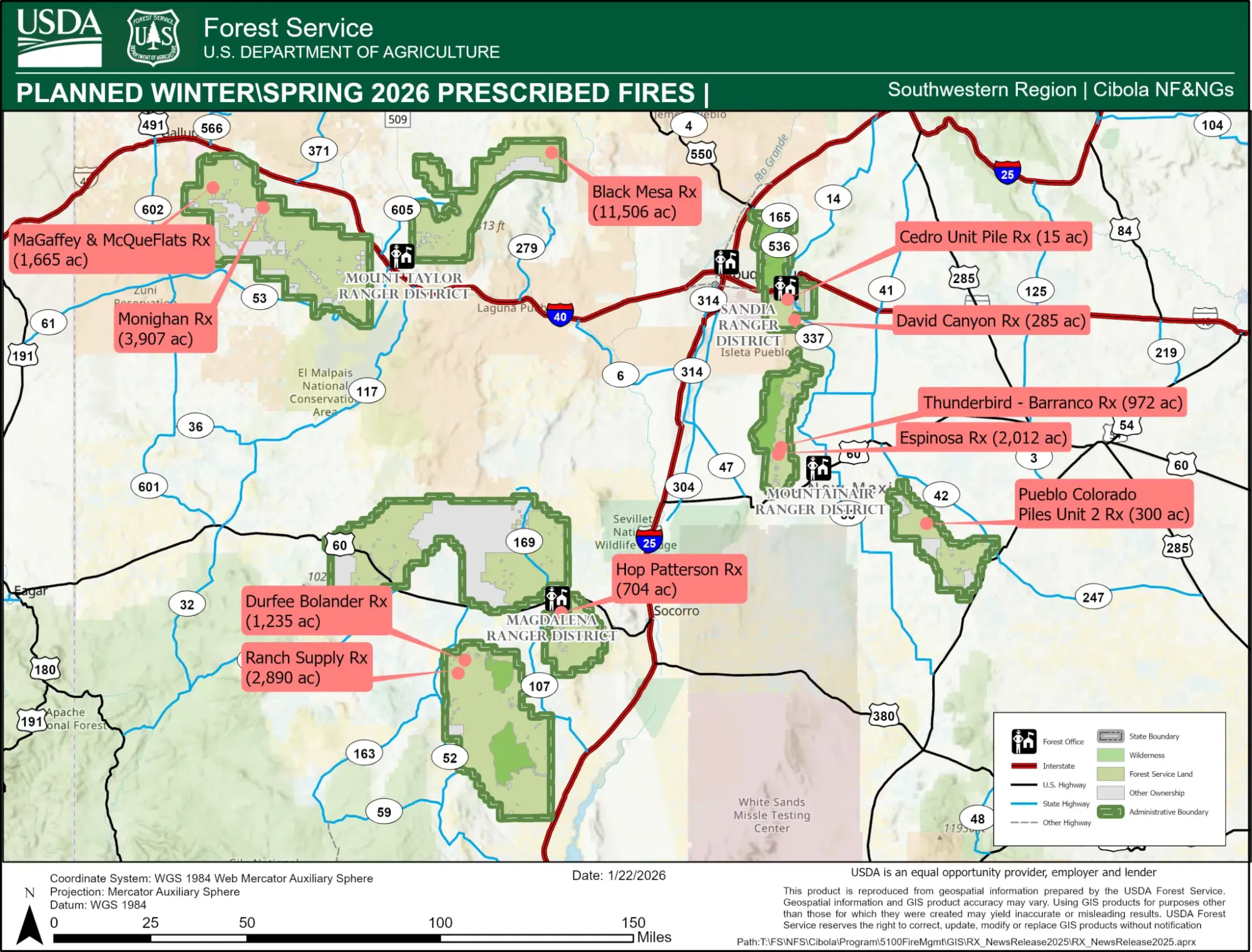
Planned projects include:
- Magdalena Ranger District:
The Hop Patterson Prescribed Fire will treat approximately 704 acres using broadcast and pile burning near Hop and Patterson Canyon. Smoke may be visible from Magdalena and Alamo. - Mountainair Ranger District:
The Pueblo Colorado Prescribed Pile Fire Unit 2 will involve up to 300 acres of piled material in the Gallinas Mountains near Willard and Corona. Smoke may be visible from Mountainair, Willard, Cedarvale, Corona, and the Estancia Valley. - Mt. Taylor Ranger District:
Several large projects are planned, including the Monighan Prescribed Fire (approximately 3,900 acres), the Black Mesa Prescribed Fire (approximately 11,500 acres), and the McGaffey and McQue Flats Prescribed Fire (approximately 1,665 acres). Smoke from these burns may be visible from communities including Ramah, Grants, Gallup, and surrounding areas.
(See image, above, for a depiction of the locations of prescribed burns.)
Additional prescribed fire projects may also occur in the Magdalena, Mountainair, and Sandia ranger districts. Depending on weather conditions, smoke could be visible in areas such as Albuquerque, Tijeras, Edgewood, Moriarty, Datil, and nearby communities.
Forest Service officials say the burns are intended to reduce overgrown vegetation that contributes to high-severity wildfires, improve forest and grassland health, and protect nearby communities. County emergency managers will be notified when ignitions begin, and temporary closures may be implemented near burn areas for public safety.
Gran Quivira Unit Prescribed Burn
At the Salinas Pueblo Missions National Monument, National Park Service staff are preparing a possible prescribed fire at the Gran Quivira Unit, located south of Mountainair. The burn is tentatively scheduled to take place between January 27, 2026, and February 28, 2026, and will treat approximately 100 acres of mechanical thinning piles.
The purpose of the burn is to reduce surface fuels created during previous restoration work and lower the risk of future wildfire spread. No established trails within the Gran Quivira Unit fall inside the burn boundaries.
Smoke may be visible from NM-55 and nearby areas during burn operations, particularly during midday hours. Cooler nighttime temperatures may allow smoke to settle into low-lying areas. In a press release, the National Park Service emphasized that ignitions will only occur under conditions that meet air-quality and safety requirements.
Following the burn, nearby pinyon and juniper trees may show brown or red needles on lower branches. According to park officials, this is a normal and temporary effect that helps open the forest canopy, promote ground vegetation growth, and reduce ladder fuels.
Specific ignition dates will be announced through the monument’s website and social media channels once conditions are confirmed.
What Residents Should Know
Residents near prescribed fire areas should be aware of the following:
- Smoke may be visible in nearby communities on burn days and for a short time afterward.
- Air quality conditions can change quickly, and individuals with respiratory sensitivities may wish to take precautions.
- Smoke can reduce visibility on roadways; drivers are encouraged to slow down and use headlights when traveling through affected areas.